Blog

News & Updates on the Berkeley Pit


Water level rising more slowly than originally projected

Water level rising more slowly than originally projected

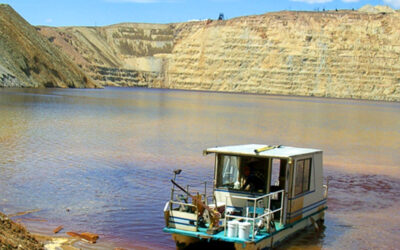
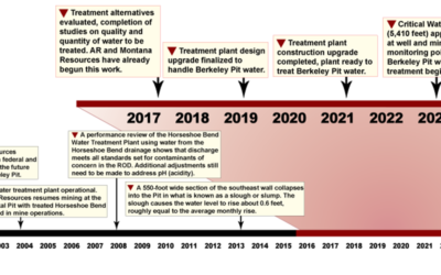
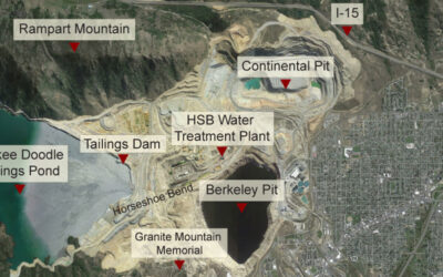
Since the Berkeley Pit was designated as a Superfund site in the 1980s, things have gone largely as expected. In one instance the site remedy has proceeded at a faster pace than mandated in the 1994 Record of Decision (or ROD, available in its entirety here). The ROD...

read more
Drones in the works for water quality sampling

Drones in the works for water quality sampling

Montana Resources and Atlantic Richfield are currently funding a Montana Tech graduate student to develop a remote system to sample Pit water quality. The student will review options to collect the required data, including aerial or water-based drones that can be...

read more
Plan for treatment technology assessment

Plan for treatment technology assessment

The guiding documents for Pit management require ongoing assessment and evaluation of the Horseshoe Bend Water Treatment Plant and the technology used to treat contaminated Pit water until several years prior to full-scale implementation. That implementation is...

read more
Maps of Berkeley Pit Monitoring Sites

Maps of Berkeley Pit Monitoring Sites

Maps from the Montana Bureau of Mines & Geology (MBMG) showing Berkeley Pit-related alluvial and bedrock monitoring sites have been added to PitWatch.Org. View snapshots of the maps below, click on an image to view a larger version, or use the links at the bottom...

read more
Computer Model Shows Berkeley Pit & Butte Mine Tunnels

Computer Model Shows Berkeley Pit & Butte Mine Tunnels

The Montana Bureau of Mines & Geology (MBMG) developed this computer model showing Butte topography and the corresponding underground tunnels from the years of historic underground mining. The red dots at the surface and red lines below represent vertical shafts,...

read more